Suelynn Choy

Professor Suelynn Choy

Professor

Black background. Multiple coloured clouds in the foreground. Colours range from white, pink, green, and blue.
Open to:

Suelynn Choy specialises in applications and methods of accurate and reliable positioning, and satellite remote sensing of the Earth atmosphere.

Overview

Suelynn Choy is Professor of Satellite Navigation in RMIT University and Director of the RMIT Satellite Positioning for Atmosphere, Climate and Environment (SPACE) Research Centre

Suelynn holds a PhD in precise Global Navigation Satellite Systems (GNSS) from RMIT University. Her research interests are concentrated in the field of precise satellite positioning and navigation, geodesy, and the use of geospatial and satellite technologies for disaster management and atmospheric remote sensing. Suelynn has authored numerous publications, contributed to industry collaborations in this area, and advised national and international committees on satellite navigation and positioning.

Web

Research

Her research focuses on Global Navigation Satellite Systems (GNSS) and their applications:

  • Accurate and reliable positioning of objects using satellite navigation systems such as GPS
  • Satellite remote sensing of atmospheric environment for meteorological and climate studies
  • Satellite communication technology as disaster/emergency warning systems

Research keywords

Global Navigation Satellite Systems, Precise positioning, Navigation, Satellite based augmentation systems, Earth observation, Atmospheric sensing

Research output summary

80

Publications

$3.6 million

Grants

7

Awards

Web

Supervisor interest areas

  • GNSS precise positioning and navigation
  • Satellite remote sensing of atmospheric environment for meteorological and climate studies
  • GNSS applications and methods

Supervisor projects

  • Positioning integrity metrics for driverless cars
  • Multi-GNSS atmospheric remote sensing for monitoring of severe weather and climate risks
  • Application of disaster risk analyses for indicating disaster risk and informing resilient risk management in Pacific Island countries
  • Multi-Hazard Early Warning Systems for Disaster Risk Reduction in Pacific Island Countries
  • Investigating the potential of blending satellite rainfall data with station gauge data over Australia and Papua New Guinea
  • Modelling of spatio-temporal variation in urban extreme rainfall events with special focus on localised versus large scale impacts
  • A machine learning based solution for Space Situational Awareness and Space sustainability

Feature publications

Uncovering common misconceptions in GNSS Precise Point Positioning and its future prospect

GPS Solutions 21 (1): 13-22

Choy S, Bisnath S, Rizos C. (2017).

Real‐time retrieval of precipitable water vapor from GPS precise point positioning

Journal of geophysical research: atmospheres 119 (16): 10044-10057

Yuan Y, Zhang K, Rohm W, Choy S, Norman R, Wang C .(2014).

GPS sensing of precipitable water vapour during the March 2010 Melbourne storm

Advances in Space Research 52 (9): 1688-1699

Choy S, Wang C, Zhang K, Kuleshov Y. (2013).

Key publications by year

Web

Feature projects

Ionospheric Modelling for the Australian Government Analysis Centre Software (ACS) and National Positioning infrastructure (NPI)

 FrontierSI. Funding - A$385,000

2019 - 2021

Precise Point Positioning service channel definition and standardization

Thales Australia. Funding - A$100,000

2019 - 2020

Effective Utilisation of Radio Waves using the Advanced Positioning Signal Provided by the Quasi-Zenith Satellite System (QZSS) Augmentation System

Japanese Ministry of Internal Affairs and Communications. Funding - A$205,000

2014 - 2015 

Key projects by year

  • Ionospheric Modelling for the Australian Government Analysis Centre Software (ACS) and National Positioning infrastructure (NPI)
    FrontierSI. Funding: A$385,000
    2019-2021 
  • Precise Point Positioning service channel definition and standardization 
    Thales Australia. Funding: A$100,000
    2019-2020

  • Integrity Monitoring System Design for the Multi-GNSS Analysis Centre Software (ACS)
    FrontierSI. Funding: A$330,000
    2017-2019
  • Highly Automated Driving with SBAS Trial: A collaborative project between VicRoads
    FrontierSI. Bosch, Transport Accident Commission and RMIT University.
    Funding: A$83,000
    2017 - 2018 
  • Assessing dual-frequency multi-constellation SBAS and SBAS-aided Precise Point Positioning for survey and/or mapping applications in Victoria:
    Department of Environment, Land, Water and Planning of Victoria, FontierSI RMIT University. Funding: A$30,000
    2017-2018

  • Satellite Delivery of Augmented Positioning Data for PPP and PPP-RTK Services in Australia and New Zealand
    Cooperative Research Centre for Spatial Information. Funding: A$400,000
    2015-2018

  • QZS Message Function Usage in Australia
    Japanese Ministry of Internal Affairs and Communications. Funding: A$24,000
    2014 - 2015
  • Effective Utilisation of Radio Waves using the Advanced Positioning Signal
    Provided by the Quasi-Zenith Satellite System (QZSS) Augmentation System

    Japanese Ministry of Internal Affairs and Communications. Funding: A$205,000
    2014 - 2015
  • Strengthening the Severe Weather Prediction Using the Advanced Victorian Regional Global Navigation Satellite System
    Natural Disaster Resilience Grants Scheme Victoria. Funding: A$260,000
    2014 - 2015

  • High Accuracy Real-Time Positioning Utilising the Japanese Quasi-Zenith Satellite System (QZSS) Augmentation System
    Cooperative Research Centre for Spatial Information. Funding: A$354,000
    2013 - 2015

  • Challenges and Prospects of Utilising QZSS Satellites in Australia
    Japan Aerospace Exploration Agency’s Multi-GNSS Joint Experiment. Funding: A$30,000
    2012 - 2013 

  • New Carrier Phase Processing Strategies for Achieving Precise and Reliable Multi-Satellite, Multi-Frequency GNSS/RNSS Positioning in Australia
    Cooperative Research Centre for Spatial Information. Funding: A$1,484,000
    2011 - 2015
Web

Awards

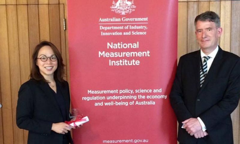
Suelynn Choy and another person standing on either side of a banner about the institute. Both are posing and smiling towards the camera.. Suelynn is holding a rolled up paper tied with a red bow in her hands.

2016 The Australian National Measurement Institute (NMI) Prize

Award date: 2016

Recipients: Suelynn Choy


2012 The J. G. Gillespie Gold Medal Prize

Award date: 2012

Recipients: Suelynn Choy

2018 RMIT School of Science Leadership Award

Award date: 2018

Recipients: Suelynn Choy

2016 RMIT Award for Research Impact (Technology)

Award date: 2016

Recipients: Suelynn Choy

Key awards by year

  • 2016 RMIT Award for Research Impact (Technology)
    Awarded by RMIT University in recognition of research achieving considerable impact outside the academic community.

  • 2015 CASS Travel Grant
    Awarded for travel to the International Federation of Surveyors (FIG) Working Week in Sofia, Bulgaria.

  • 2013 Australia-China Young Researchers Exchange Program
    Awarded by the Australian Department of Industry, Innovation, Science, Research and Tertiary Education and the Chinese Ministry of Science and Technology, to facilitate science and research collaborations between the two countries.

  • 2012 The J. G. Gillespie Gold Medal Prize
    Awarded by the Institute of Surveyor Victoria in recognition of outstanding achievements of RMIT graduates in the broader discipline of surveying and to honour qualities that reflect credit on the profession.

  • 2011 The Ian Potter Foundation Travel Grant
    Awarded for travel to the Institute of Navigation (ION) Conference in Portland, USA.
Web

Grants

See 'Projects'

Web
aboriginal flag
torres strait flag

Acknowledgement of Country

RMIT University acknowledges the people of the Woi wurrung and Boon wurrung language groups of the eastern Kulin Nation on whose unceded lands we conduct the business of the University. RMIT University respectfully acknowledges their Ancestors and Elders, past and present. RMIT also acknowledges the Traditional Custodians and their Ancestors of the lands and waters across Australia where we conduct our business - Artwork 'Luwaytini' by Mark Cleaver, Palawa.

aboriginal flag
torres strait flag

Acknowledgement of Country

RMIT University acknowledges the people of the Woi wurrung and Boon wurrung language groups of the eastern Kulin Nation on whose unceded lands we conduct the business of the University. RMIT University respectfully acknowledges their Ancestors and Elders, past and present. RMIT also acknowledges the Traditional Custodians and their Ancestors of the lands and waters across Australia where we conduct our business.