Using the same underground optical fibres that transmit our internet, researchers think they will be able to measure our Earth’s tremors more accurately than ever before.
The challenge: Mapping Australia’s subsurface at a more granular level than ever before
Seismometers – the scientific instruments that measure ground motion – are vital to understanding earthquakes in Australia. Seismometers record data to determine the location and severity of each tremor, which help us to make maps of the Earth’s subsurface. These data and maps can then be further used to make informed decisions such as assessing how our natural resources like water and critical metals are changing over time.
However, across Australia there are more than 100 permanent seismometers (of which 50 are in Australian schools), sometimes placed between tens and hundreds of kilometres apart in cities, and even up to thousands of kilometres apart in rural areas. Seismometers are also bulky, expensive pieces of equipment that require experts to install, so having the ability and resources to install them in densely populated areas is a major challenge.
With such sparsely located equipment, it is very difficult to pinpoint the exact location of an earthquake.
Our response: Using our internet’s optical fibres under Melbourne’s footpaths to measure seismic vibrations
Instead of the need to install new instrumentation, earth scientists and data communication specialists have partnered to use the sensitive optical fibres underneath Melbourne as seismometers. Optical fibres are already laid all around Australia and transfer our internet via light pulses, which is very sensitive to vibration – making it perfect to record our Earth’s tremors.
The experiment repurposes long sections between one to tens of kilometres of fibre optic cable into thousands of individual sensors at meter spacing and uses light to measure the ground motion as seismic waves pass through the fibre. This means the team now have access to much more granular seismic pulses of the Earth than ever before.
ANU seismologists Meghan Miller and Voon Hui Lai have teamed up with data communication specialists Arnan Mitchell, Andreas Boes and Sim Tan from RMIT and the University of Adelaide to measure our Earth’s tiny vibrations using the same optical fibres that transmit our internet.
Thanks to a laboratory that spans the whole Melbourne metropolitan area – called the Australian Lightwave Infrastructure Research Testbed (ALIRT)* – the team can access a small portion of Melbourne’s optical fibre network for collaborative research.
The testbed consists of a continuous 76.6km loop of fibre formed from already-installed fibre – just like the fibre being used in the NBN.
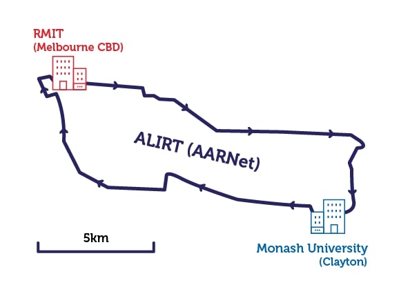 Map of ALIRT's test zone within Melbourne metropolitan area
The experiment so far: Using a sledgehammer to map Melbourne’s optical fibre network
With a Google map of where the optical fibre testbed lay, the researchers walked the footpath above the cables, then used a sledgehammer to create a vibration into the subsurface. By detecting the vibrations on the optical fibre and distinguishing them from the sledgehammer from nearby cars and trams, the team could accurately map the position of the fibre at depth.
With direct, real-time access to the optical fibre testbed from the Integrated Photonics and Applications Centre laboratory at RMIT University in the Melbourne CBD, the team isolated the hits of the sledgehammer, the noise of tram and car vibrations on the road, local earthquakes and distant ones.
These preliminary results suggest that the team will be able to use the various vibrations on the fibre to create maps of what lies beneath Melbourne – from the paleochannel of the Yarra River to the depth of the Earth’s crust.
Collecting more data could also allow the team to use these optical fibres to measure heavy rainfall to supplement measurements at meteorological stations, to assess the vast volumes of water going through our storm drains, and to better locate very small future earthquakes. It could also help us to identify important natural resources such as water and critical metals in a non-invasive, cost-effective way to observe movements in the Earth’s subsurface.


Next steps: Mapping the optical fibre underground to what’s happening above ground
At metre-long intervals in the new sensor system, the team now need to create an accurate map of what is happening in the optical fibre. The need to ‘match’ what is happening underneath the footpaths to the sledgehammer ‘taps’ to detect for variables like the extra loops at various manholes used for maintenance. These loops can range from two metres to a hundred metres in extra optical fibre and can cause mammoth variability in the data because of vibrations being overamplified.
The other issue is that optical fibre has bends in it – which can affect how the vibration is recorded. The team need to ensure that they fully understand and can correct for all these optical fibre loops and kinks before interpreting these data.
Team
- Meghan Miller, ANU: observational seismologist that seeks to understand the structural and dynamical evolution of the Earth.
- Voon Hui Lai, ANU: observational seismologist understanding the underlying processes in natural hazards (volcanic eruption, debris flow, earthquakes).
- Arnan Mitchell, RMIT: integrated photonics expert who works with academics and industry to create technology solutions with real world impact.
- Andreas Boes, University of Adelaide: photonics engineer who specialises in photonic integrated circuits and optical frequency combs and their use for precision measurements.
- Mengxi (Sim) Tan, RMIT University: photonics engineer who aims to make data communications transfer faster and more accurate, all with smaller infrastructure.

This research was made possible thanks to funding from AuScope and the Federal Government as a part of the National Collaborative Research Infrastructure Strategy (NCRIS).
* ALIRT is part of the InPAC laboratories linking RMIT and Monash University. The testbed was established under ARC Linkage Infrastructure and Equipment Funds LE170100160 as a collaboration between RMIT, Monash, Swinburne and AARNET.