

Building community capability to understand and respond to urban heat

What happens when people are given the tools to measure heat in their own neighbourhoods? RMIT researchers helped more than 1,200 Australians investigate local heat conditions, building community capability to understand how surface materials, vegetation, shade and urban form shape local microclimates.

Artificial grass can become much hotter than natural grass on a hot day. Rubber playground surfaces can also reach very high temperatures, while shade and vegetation can make outdoor spaces more comfortable.

These were some of the differences in urban heat that participants in RMIT’s Citizen Science Urban Microclimate Project discovered by measuring temperature, humidity, wind and surface conditions in their own neighbourhoods.

Rather than simply learning about urban heat from researchers, participants collected and interpreted data themselves. This gave them first-hand experience of how surface materials, vegetation, shade and urban form influence local conditions, turning urban heat from an abstract climate issue into something they could see, measure and understand.

A reflection by an Adelaide-based resident highlights the value of this experience:

‘Citizen science initiatives like the Urban Microclimate Citizen Science Project have a role in addressing the complex and interrelated challenges of our time…[It] creates ripples of public education and engagement across sectors, from climate change to health and beyond. This is the butterfly effect of citizen science, where small actions catalyse far-reaching, positive changes across interconnected systems.’ 

Impact at a glance

  • Community participation: 1,200 citizen scientists engaged 
  • National reach: 21 councils across five states and two territories 
  • Hands-on research: 55 outdoor microclimate experiments 
  • Citizen-generated evidence: around 6,000 data points collected 
  • Lasting capability: open data, sensors and tools enabling continued investigation

Turning research into practical experience

Led by Professor Priya Rajagopalan, the research team included Associate Professor Mary Myla Andamon, Dr Andrew Carre, Associate Professor Ruwini Edirisinghe (RMIT), Professor Mat Santamouris and Associate Professor Riccardo Paolini (University of New South Wales). They were awarded $355,000 by the Department of Industry, Innovation and Science through its Citizen Science Grants program to enable community participation in scientific research projects that have a national impact.

As Professor Rajagopalan explained, ‘Extreme heat is a hyper-local threat that is not normally captured by standard weather reports. Localized data allows residents and policymakers to identify exactly where intervention is needed most. Empowering local governments and communities with data enable them to adapt and respond to rising temperatures.’

Between 2017 and 2021, the team worked with RMIT’s Sustainable Building Innovation Lab and the University of New South Wales’ High Performance Architecture Centre to design systems that measure urban heat islands, overheating and local climate changes in cities.

These included low-cost sensors and high precision measurement equipment, standardised measurement protocols, instructional resources, a mobile application and the Outdoor Thermal Comfort Tool, which enabled participants to investigate how factors such as surface materials, vegetation, shade and urban form influence local microclimate. They also developed an open-source database and the Urban Heat Island Mitigation Decision-Support Tool (UHI-DS) which provides visualisation of the results of studies for several exemplar projects. All resources are freely accessible on the project website.

Making urban heat visible

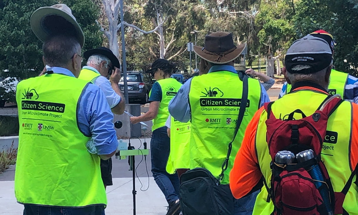
Across 55 field events, more than 1,200 citizens from 21 local councils contributed around 6,000 data points. Measurement locations reflected different demographic and physical characteristics, including urban form, surface materials, vegetation and exposure.

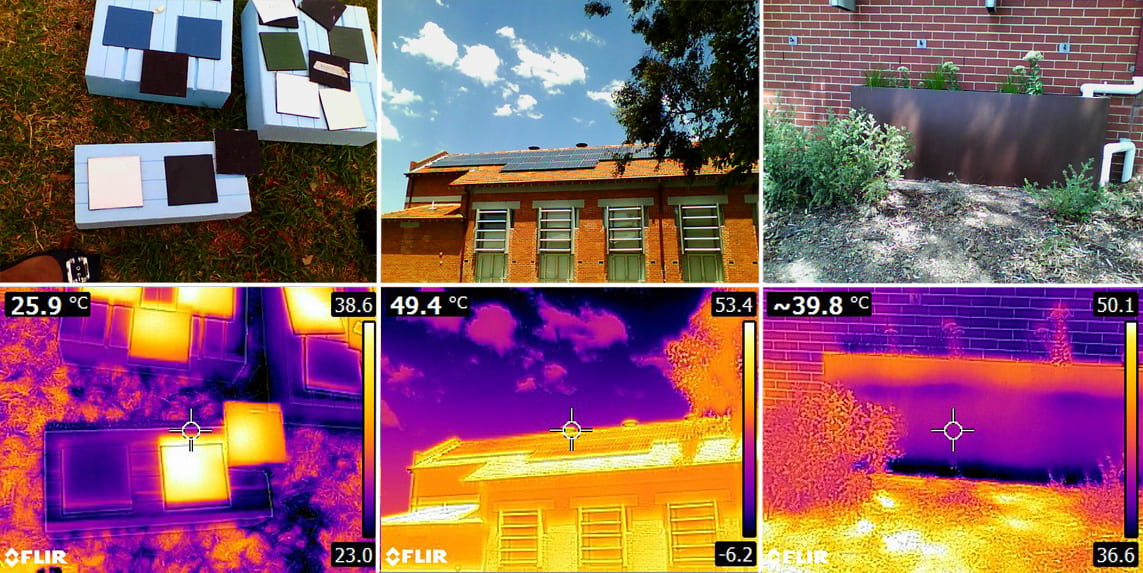
  Infrared thermal images (bottom row) of samples building materials and buildings (top row). Infrared thermal images (bottom row) of samples building materials and buildings (top row).
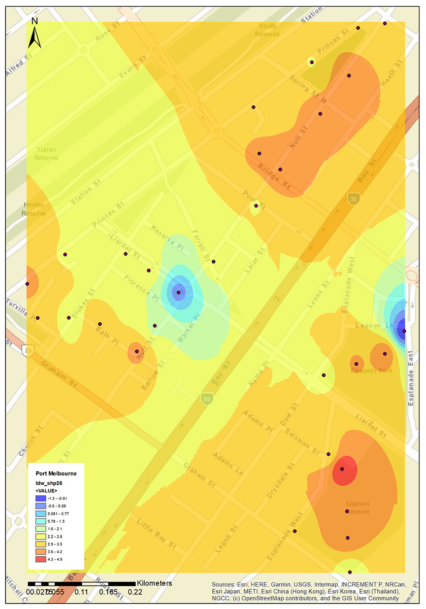
The urban heat island (UHI) profile of Port Philip Neighbourhood Centre on 24 February 2019, with the colours representing UHI intensity, calculated by subtracting the air temperature of the reference meteorological station from the air temperature measured by the citizens at each location (black dots on the map) on 24 February 2019, between 1:00-3:00pm.The urban heat island (UHI) profile of Port Philip Neighbourhood Centre on 24 February 2019, with the colours representing UHI intensity, calculated by subtracting the air temperature of the reference meteorological station from the air temperature measured by the citizens at each location (black dots on the map) on 24 February 2019, between 1:00-3:00pm.

For participants, the measurements provided a practical way to understand why some places feel hotter than others. They could investigate differences between artificial and natural grass, see how hot playground surfaces become and observe the effects of shade and vegetation.

The project therefore built capability through doing, giving community members practical experience in collecting, comparing and interpreting environmental data. The project report noted that the measurements helped citizens develop a more thorough understanding of the factors influencing local temperature, humidity, wind speed and surface temperature.

The engagement also gave researchers insights into how people without scientific backgrounds respond to scientific experiments, helping inform future approaches to citizen science.

Connecting communities and councils

The project engaged communities through 21 local councils across five states and two territories.

For councils, the project provided access to localised microclimate data, citizen-science methodologies and practical tools for exploring urban heat. The Urban Heat Island Mitigation Tool was designed to help citizens and councils consider measures suited to specific areas and climatic conditions.

The City of Bayswater in Western Australia was among the early councils to participate. As part of its Citizen Science Project Week in February 2019, residents measured microclimate conditions in local wetlands. Mayor Dan Bull said the results could potentially guide future planning responses, including tree planting, building materials and the design of town centres to reduce urban heat.

The project report concludes that citizen-generated data has the potential to help local governments identify areas affected by factors such as limited vegetation and inappropriate surface materials and inform where mitigation resources could be directed.

Building understanding for future action

The project's most clearly demonstrated impact was increasing awareness, understanding and scientific capability among participating communities.

By giving citizens the tools to investigate heat in places they know and experience, the project helped communities understand the relationship between the built environment and local microclimate. It also gave participants practical experience in applying scientific methods to a real-world environmental challenge.

The project created resources that can support continued learning and exploration beyond the project’s field events. Its website continues to provide access to instructional resources, data and tools. The Western Sydney Regional Organisation of Councils (WSROC) website continues to list the Citizen Science Urban Microclimate Project among its Heat Resilience Program resources. In addition, secondary schools continue to approach the team for sensors to conduct experiments for their science projects.

The project established a foundation for ongoing research in this field. Through her leadership of RMIT’s Post-Carbon Research Centre, Professor Rajagopalan continues to investigate solutions for urban microclimate mitigation, human thermal comfort, building energy performance and climate-resilient built environments, to provide ongoing pathways for research knowledge to inform practical responses to climate change.

As Professor Rajagopalan said, ‘The impacts of this project span public health, urban planning, policy-making, and community resilience. Local councils can implement targeted cooling interventions and plan strategic green infrastructure. They can also forecast localised heat stress and protect vulnerable population during extreme heat events.’

Further information

Contact

Professor Priya Rajagopalan

Professor Priya Rajagopalan

Associate Dean (Research and Innovation)

Read related RMIT impact stories


Connect with RMIT Research

If you're not sure how you can best work with us, our team can explain what's possible and put you in touch with the right person. 

aboriginal flag float-starttorres strait flag float-start

Acknowledgement of Country

RMIT University acknowledges the people of the Woi wurrung and Boon wurrung language groups of the eastern Kulin Nation on whose unceded lands we conduct the business of the University. RMIT University respectfully acknowledges their Ancestors and Elders, past and present. RMIT also acknowledges the Traditional Custodians and their Ancestors of the lands and waters across Australia where we conduct our business - Artwork 'Sentient' by Hollie Johnson, Gunaikurnai and Monero Ngarigo.

Learn more about our commitment to Aboriginal and Torres Strait Islander peoples